|
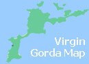
The Baths Virgin Gorda are such a spectacular natural feature that they warrant their own section. They are located at the southern end of Gorda and they are on their own a good enough reason to visit the island. The "Baths" are a collection of giant boulders which form spectacular pools and grottos which flood with sea water at high tide.
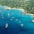
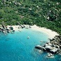
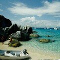
The hundreds of huge boulders and rock formations are worn smooth by rain and sea water and form a maze that leads to Devil's Bay beach. The area is a popular anchorage for visiting yachts and also a memorable day trip where you can snorkel in the clear blue water around the boulders or just chill out on the beautiful beaches.
|
| The name "baths" comes from the warm sheltered pools of water in and around the rocks which flood at high tide. Large caves and a huge tunnel through one of the boulders is a result of erosion. These features can be explored by visitors clambering inside and underneath the massive granite boulders. |
|
Cave Pool
|
Devil's Bay & Boulders
|
| The oldest rocks were thrown together as a result of volcanic eruptions. Newly formed volcanic larva on the seabed over 70 million years ago eventually turned to granite and around 20 million years ago a fault occurred on the seabed and the rocks which we see today were lifted up. The boulders would have been much larger and worn down and rounded by millions of years of erosion from rain, wind and the sea. |
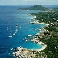
| The photo above shows the fine view from the restaurant at the top of the hill (Tortola is on the left, Beef Island in the Centre and Scrub Island to the Right with Great Camanoe behind). |
| The area covered by boulders is around half a mile long and covers the baths itself and neighbouring Devil's Bay to the south and Spring Bay and Big Trunk Bay to the north. We have used one of our aerial photos to overlay with text to show an aerial photo map of the baths. |
|
View from the top of the hill
|
Restaurant
|
| Getting there: From Tortola Ferry Dock there are regular boats to the Virgin Gorda boat dock (thirty minutes) where you can pick up a taxi to The Baths (10 minutes). Two ferry operators offer day trips for around $25 / $30 per person. Entrance is around $3 from the National Parks Trust kiosk at the top of the hill. |
|
|
|
|
|
|
|
|
More photographs
of The Baths
|
|
|
|
Cruise Port Guide
|
|
|